Tiempo severo USA 22-23/09/2010
Publicado: Mié Sep 22, 2010 2:47 pm
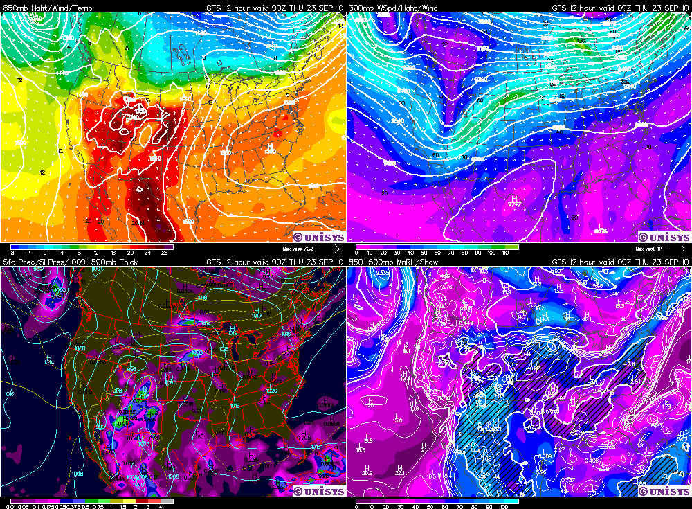
Otro frente frío fuerte, para la época del año, avanzará sobre los estados del Norte y dará condiciones favorables para el tiempo severo en el día de hoy Miércoles. Hoy se esperan algunos tornados y fuertes granizadas, y mañana, dado el muy fuerte flujo en capas bajas, se esperan algunos tornados pero menor cantidad de granizo, porque la humedad tropical de la tormenta tropical Georgette se va a mover por delante del frente frío y va a producir agua precipitable de hasta 60 mm sobre los estados del Norte, y esto va a generar un ambiente poco probable para el granizo importante, pero eso mañana recién, hoy si lindas piedras!
Les dejo algunas cosas!
(Hay una zona también con pronóstico de tiempo severo en la costa este, pero más débil que en el centro-Norte)
..there is a slight risk of severe thunderstorms over portions of the northern and
Central Plains into upper Midwest...
..there is a slight risk of severe thunderstorms over central/southern New England into
the Middle Atlantic States...
..nrn/Central Plains into the upper Midwest...
Elevated...strong to severe thunderstorms in progress this morning over northestern
Nebraska/southeastern South Dakota are expected to move/develop eastward/northeastward today into
central/southern Minnesota/northern Iowa in advance of midlevel impulse translating east-northeastward
across SD/neb. Forcing associated with this feature coupled with an
enhanced zone of warm thermal and moisture advections along south-southwesterly
low level jet strengthening to 40-50 knots will sustain an environment
characterized by MUCAPE of 1500-3000 j/kg --ref. 12z oax/lbf
soundings-- and sufficient cloud-bearing shear to support supercells
capable of mainly large hail to the north of retreating warm front.
Within system warm sector...the combination of strong daytime
heating...boundary layer dew points in the 60s to around 70f and
steep lapse rates will contribute to a moderately unstable...but
capped air mass with MLCAPE increasing to 1500-2500 j/kg. Given the
early east-northeastward progression of above-mentioned short wave trough along
northern extension of the developing warm sector over neb/IA...there is
some uncertainty as to how surface-based... diurnally-enhanced thunderstorm
activity will evolve. Current thinking is that perhaps the southward
extension of persistent...elevated thunderstorm complex will become
progressively more surface-based as synoptic warm front retreats northward
through Nebraska/Iowa toward the South Dakota/Minnesota borders.
Any storms that can become rooted in the boundary layer will
experience a moist and strongly sheared lower-tropospheric
environment in vicinity of of warm front where a few tornadoes will be
possible in addition to large hail and damaging wind gusts.
Additional...diurnally-enhanced storms will be possible in advance
of deepening Lee cyclone over western Nebraska where environment will also be
supportive of supercells capable of large hail...damaging winds and
perhaps a couple tornadoes.
Strong/severe thunderstorms are expected to continue overnight...perhaps
expanding in areal coverage...in association with next significant
short wave trough which will emerge from the Central High plains in
advance of Great Basin large-scale trough. Large hail and strong
wind gusts will be the primary hazards with the most intense storms.
..cntrl/southern New England into the Middle Atlantic States...
12z upper-air analysis and morning water vapor imagery indicate a
short wave trough over the lower Great Lakes and upper Ohio Valley
will progress eastward today in tandem with surface cold front through
the region. While the ambient pre-frontal air mass is not overly
moist...visible satellite imagery suggests that strong diabatic
heating should occur...contributing to steepening lapse rates and
MLCAPE values increasing to 1000-1500 j/kg. Forcing for ascent
associated with short wave trough and frontal uplift should Foster
scattered thunderstorm development by afternoon along/ahead of cold front
over central/eastern parts of New York/PA with additional...more isolated storm
formation southward along Lee trough situated over the Piedmont.
Forecast soundings indicate strengthening west-southwesterly/westerly tropospheric
flow with the approach of the short wave trough with setup becoming
increasingly favorable of bowing line segments capable of mainly
damaging wind gusts through this evening. Vertical shear is
expected to diminish with southward extent along the Lee trough...though
thermodynamic environment will still be supportive of locally strong
winds.
..ern Great Basin...
Large-scale forcing for ascent is forecast to steadily strengthen
over the region today in advance of large-scale trough progressing
eastward through California/Nevada and the lower Colorado valley. At the same
time...intensifying surface cyclone over western Utah will begin to draw
the northern extension of Gulf of California moisture surge currently observed
over central/southern Arizona into the area...supporting modest air mass
destabilization through the diurnal heating cycle. Given the
concurrent increase in vertical shear and dynamic forcing for
ascent...setup will favor the development of a few strong to
marginally severe storms along/ahead of Pacific front with a risk
for locally damaging wind gusts and perhaps some hail.