Una violenta onda corta se moverá desde esta noche y especialmente durante el día de mañana Lunes sobre la zona, produciendo que el frente, actualmente frío y sobre el Golfo de México, se mueva muy rápido como cálido sobre los estados de Texas, Oklahoma, Arkansas y Kansas.
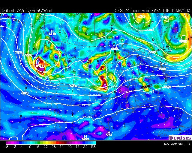
Los modelos son EXPLOSIVOS con esta situación, porque producen la llegada de la intensa humedad desde el golfo, mezclando a la misma con aire muy frío en niveles medios y altos, producido por la onda corta. La inestabilidad pronosticada entonces por estos modelos es bestial. Miren los mapas que les dejo a continuación, que son del GFS para mañana a la noche:
500 hPa:
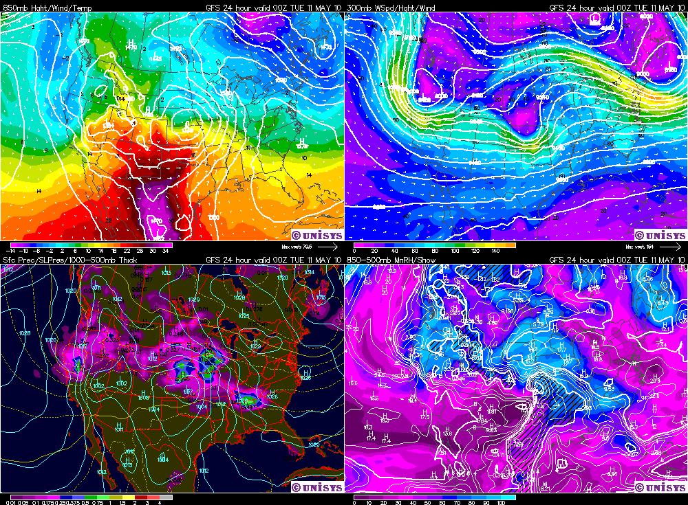
4 Paneles:
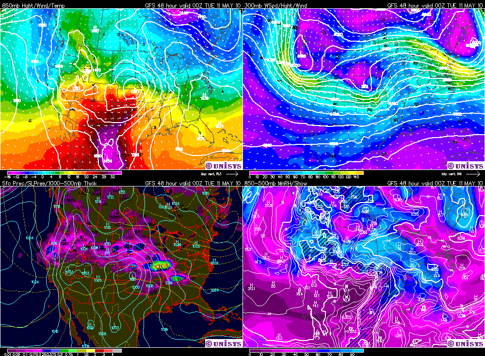
Es impresionante como se ve el frente cálido en 850 hPa, pasando de temperaturas de -4ºC a 22ºC en unos pocos cientos de kilómetros!. por el otro lado noten la inestabilidad y noten como los jet se cruzan en la zona de máxima inestabilidad (que es la zona que ya hoy tiene riesgo moderado (en camino a riesgo alto mañana). Pero vean una cosa más, miren el LIFTED que pronotica el modelo NAM (que es la versión del WRF mejorada que están usando por allá) para mañana a la noche, pongan bien el ojo
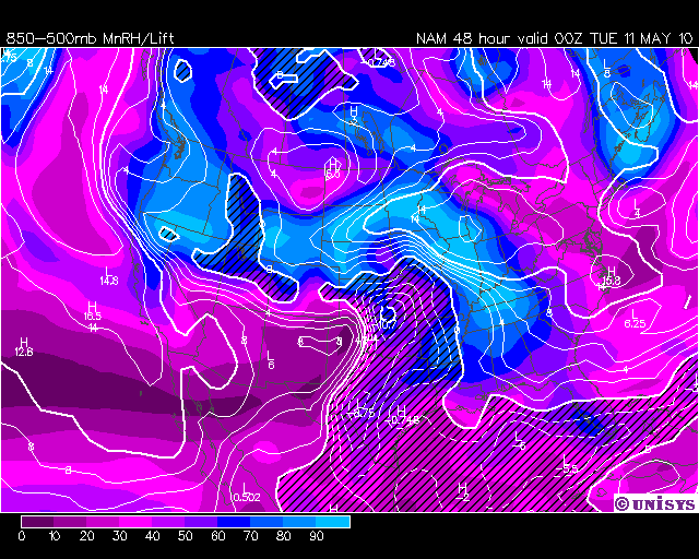
-10.7!!!!!!!
Encima dicen que estas situaciones, de este tipo, estadísticamente les producen muchos tornados violentos, por lo que estan hasta las ......
Les dejo la discusión y el mapa de tiempo severo para mañana, pero me parece que mañana van a estar más que de joda
Day 2 convective outlook
National Weather Service Storm Prediction Center Norman OK
1236 am CDT sun may 09 2010
Valid 101200z - 111200z
..there is a MDT risk of severe thunderstorms across north central/NE OK...Scntrl/se
Kansas and extreme SW MO...
..there is a slight risk of severe thunderstorms from the central/Southern Plains to
the middle-MS valley...
***supercells with long-track strong tornadoes and very large hail
expected Monday late afternoon/evening across parts of central/north OK...southeast Kansas
and SW mo***
..cntrl/Southern Plains to the middle-MS valley...
Water vapor shows a healthy middle-level shortwave trough approaching the
central/northern California coast Sunday morning. Feature will reach The
Four-Corners region Monday morning and the central/Southern Plains by
evening. Surface low will intensify over scntrl Kansas Monday afternoon before
translating to north MO by 12z Tuesday. To the S of the low...a dryline
will mix eastward into scntrl Kansas and western parts of Texas/OK during the afternoon
and be the impetus for thunderstorm initiation.
There still remains a slight amount of uncertainty with respect to
trough timing/surface feature placement and GFS remains on the eastern edge
of the envelope of solutions. Cannot discount that idea completely
given how Mobile/zonal the flow regime will become in the next 24-48
hours and current day 2 outlook will include elements of both 00z
NAM/GFS...most like the 12z European model (ecmwf).
Elevated convection...which may already be producing large hail
across portions of OK and eastern Kansas Monday morning...should move east-northeast
toward the middle-MS valley during the afternoon. Air mass should recover
rapidly in wake of these storms with Monday afternoon middle-60s surface dew
points surging northward through OK and into scntrl Kansas. Cinh...rather
strong initially...should weaken with the approach of DCVA...
deepening dryline circulation and strong heating. Thunderstorm initiation
will occur middle-late afternoon...most likely in scntrl Kansas and north central
OK...with more isolated storms farther S along the length of the
dryline into southwestern OK and West Texas.
As storms move out of the dryline circulation...largely
perpendicular deep-layer wind vectors...MLCAPES to 3000 j/kg and
effective shear 50-70 kts will favor discrete supercells with very
large hail. Forecast hodographs exhibit very strong low-level srh in
excess of 400 m2/s2 and given anticipated storm Mode...increase in
the nocturnal evening low level jet and lowering LCL/S...long-track strong
tornadoes will be possible... particularly from OK portion of
I-40/44 northward into scntrl/southeastern Kansas during the early evening.
Warm sector will rapidly recover downstream of early evening
activity into southwestern MO and set-up appears conducive to support
discrete supercells well into the evening. Eventually...activity
will transition into lines/clusters overnight with damaging
winds...isolated tornadoes and large hail probabilities as far east as the
middle-MS River Valley by 12z Tuesday.
Farther S...supercells that may form across SW OK into West Texas will
diminish during the early evening as stronger forcing exits to the north
of the region.